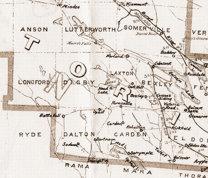
Longford, Digby, and Dalton have a few streams of considerable size, two branches of Black River flowing westward through the two last mentioned townships. Digby also has a branch of Gull River, and Head lake lies on the boundary between it and Laxton, divided from Somerville by Gull River and Mud Turtle Lake. From Deer Lake and Perch Lake, in Laxton, the Talbot River and Perch Creek flow into Bexley, in which township they unite below Raven Lake. Bexley is very irregular in shape by reason of the many deep indentations of Balsam Lake, which , with Gull River, divides it from Somerville. Grand Island, in Balsam Lake, belongs mostly to Bexley. From Bexley the Talbot River flows into and through the southern part of Carden, until it enters Eldon, receiving several branches. In the northwest are Upper and Lower Mud lakes, drained into dalton by Head River, which again enters the northeast corner of Carden, cuts the corner of Laxton, and flows through the southern part of Digby to the lake. Somerville is divided diagonally, from northeast to southwest by Burnt River, of which Union Creek is a branch from the east. Between Gull and Burnt Rivers lies Four Mile Lake, of which the outlet is Cobden Creek, flowing into Balsam Lake.
A portion of these waters was surveyed for a canal route in 1835 by N.H. Baird, he having two years before surveyed the lower Trent waters. Sections of his estimates related to those parts, from Bobcaygeon to Cameron's Falls and Balsam Lake, including Sturgeon Lake, Bobcaygeon Rapids, and the shallows above, with a dam there and another at the mouth of the Little Bob; and from Balsam lake to Lake Simcoe, including a collateral cut to Talbot River, locks thereon, clearing of floodwood, and piers at the mouth of Talbot Harbour. The estimates of the whole work, between lakes Ontario and Huron, footed up to 495,515 pounds sterling; but for cheapness, the engineer proposed a part water and part rail route, the idea being to use steamers to transport trains of cars. This was the inception of the Trent Valley Canal scheme.
Two preliminary arguments which led to Baird's survey brought about the first settlements along or near the proposed canal route in the north of Eldon. The earliest settler in Bexley was probably Admiral Van Sittart, who drew a large tract of land along the west shore of Balsam Lake - very pretty in its pristine wildness, but at the same time very stony. This gentleman had a waiter named Stevenson, whose daughter he married, and to her he left the bulk of his property. The Admiral had come and gone before the canal survey. Many islands in the lakes and rivers were reserved for the Indians, who in 1847 sent into goverment a claim, not only to all the islands, but also to the points of land or broken fronts , and to lands extending to the line of 45 degrees north latitude, which had not been ceded to the Crown. The only white men who came into this northern district were a few traders who had established posts to barter with the Indians for peltries. But by and by the fur trade had to give way to the timber business, and lumbering soon brought settlement. The first mill north of Cameron's Lake was built by John Bateman at Coboconk, in the early 1850's. The name is derived from the Indian, Ko-ash-kob-o-cong, and applied to the part of the river where a portage of a few rods were made. Soon after the mill was built, lands began to be taken up in the adjoining townships. Among pioneer names are those of:
BOWMAN, BRADMOUR, GROZETTE, and DENNISTON in Bexley;
BADGEROW, BUTLER, CAVANAGH, COOKMAN, CRABBE, EAD, EARL, FELL, HANNAH, HUNT, LYLE, McKAY, MCMAHON, POWERS, TAGGART, and WORKMAN in Somerville;
CONNORS, DEXTER, GILLESPIE, MURTAGH, QUIGLEY, and RICHMOND, in Carden;
ANGERS, COURTEMANCHE, CORBETT, FOLEY, POTTER, RUSSELL, RYAN, and STAPLES, in Laxton;
FOLEY, MCFAYDEN and POWERS, in Digby;
GARDINER, MONTGOMERY, and THOMPSON, in Dalton.
In Longford, cultivation is confined to farms for the supply of lumber shanties. The timber limits here were owned by John Thompson, and those in other townships by different lumberers. The FELL settlement, in Somerville, was established by people from Cavan Township, County of Durham; that by the brothers EAD, and others, on the west side. A French settlement comprised the earliest locations in Laxton, AUGUSTINE ANGIERS becoming its pioneer by settling on the shore of Mud Turtle Lake. The DEXTERS, early settlers in the northwest part of Carden, built a mill, the only one in the township. At the census of 1871 Bexley had 489 inhabitants, and 2,448 improved acres; Somerville, 1,074 inhabitants and 5,277 improved acres; Laxton, Digby, and Lonford, 850 inhabitants, and 5,120 improved acres; and Carden and Dalton, 1,027 inhabitants, and 5,233 improved acres. By 1881 Bexley, Carden, Somerville, and Dalton have increased in population less than one-half, while the other three townships remained about stationary. In 1879 Longford returned only 1 ratepayer; Digby, 32; and Laxton, 134; while the figures for Dalton were 93; Carden, 191; Bexley, 152; and Somerville, 295.
The equalized assessment valuation of the municipalities in that year was Somerville, $215,079; Bexley, $106,033; Carden and Dalton, $90,558; and Laxton, Digby, and Longford, $83,471. The lands of Bexley were valued highest in these townships, being reckoned in the 5th class at $3.75 per acre, as compared with the first class in Mariposa, at $24 per acre for assessment. Somerville lands were put in the next class at $3.50; those of Laxton and Carden next at $2.25; Digby at $1.50; and Longford in the lowest class at 60 cents per acre.
Very little of the surface of Longford is arable, and its worth in the late 1800's lay wholly in its timber. Digby produced some of the best pine ever got out of the County, but by the 1880's was pretty well culled. It has a profusion of granite; but there is some arable soil at the southwest, and a little in the south-east corner. Dalton's few settlers in the 1880's were at the south. At least two thirds of Dalton is huckleberry plain. In Carden the early settlements were to the southeast, and northwest of the tamarac and balsam plains, which occupy a large area in the centre of the township. Laxton is rough and rocky, and has very few good farms. The great drawback to agriculture in Bexley is the out-cropping of limestone and granite. In most instances, whatever soil may be on the surface is so shallow that it was utterly destoyed by burning of timber slash. Even where the soil is deepest it is freely interspersed with boulders. However, this is considered the best of the seven northern townships.
In the 1870's it gave a bonus of $15,000 to the Toronto and Nipissing Railway, which, entering at the west side, runs through the township, and across the head of West Bay, Balsam Lake to Coboconk. This village is situated on Gull River, a short distance above its debouchement into Balsam Lake. The first store was built here by Adam H. Carl; and the first public house, without liquor, was that of Amos Fern, on the Somerville side. By the early 1800's it had 5 stores, a hotel, railway station, grist and saw mills, three churches, and all the other accessories of a smart little village. Down the west shore of Balsam Lake, Mr. George Laidlaw has about a thosand acres of land, (the old Van Sittart location), which he is improving for a summer resort for the public.
Some portions of Somerville, notably the Fell and Ead settlements, are good; but the greater part is emphatically a bad country for farmers. It is the largest, and has the greatest population of any of these northern townships. It gave $15,000 to the Toronto and Nipissing, and the same amount to the Victoria Railway, which passes through it, along Burnt River, from the southwest to the northeast corner, where is situated the village of Kinmount, the principal trade centre of an extensive stretch of territory, though its commercial attractions are limited to a population of about 200. and the shops, stores, &c., which usually flourish in a backwoods village of that size.
Search the Ontario (Upper Canada) Genealogy Website - Make sure to use all known variations of a family name in your search!
Historical Visits to Ontario Villages and Towns Take a trip back in time to the late 19th century and explore the towns and villages where your ancestors lived, loved, laboured, laughed and played.
Ontario Images of the Past Thousands of Images of City, Town, Village and Country Life
Ontario Land Registry Records Research Thousands of your ancestors and where they lived in Ontario
Upper Canada (Ontario) Newspaper Notices Database
Ontario Genealogy Newspaper Notices Database
Ontario (Upper Canada) History and Pioneer Family Research
Queen's Own Rifles - Old Photos of Members
Upper Canada District Maps (Circa 1800)
Upper Canada (Ontario) History Books On-Line Index
Ontario County Directories Victoria, Haliburton, Hastings, Peterborough, Durham, Northumberland, Muskoka, and Old Ontario County
Central Upper Canada (Ontario) Marriage Database 22650 Marriage Records Indexed
Central Upper Canada Baptism Database 25000 Anglican, Methodist, Roman Catholic and Church of Scotland Marriages indexed
Upper Canada (Central Ontario) Burial Database 4500 Anglican, Roman Catholic, Methodist and Church of Scotland Burials indexed
Eastern Upper Canada Marriage Database Anglican, Roman Catholic and Church of Scotland Marriages indexed
Eastern Upper Canada Baptism Database Anglican, Roman Catholic and Church of Scotland Baptisms indexed
Eastern Upper Canada Burial Database
Upper Canada (Western Ontario) Marriage Database
Upper Canada (Western Ontario) Baptism Database
Upper Canada (Western Ontario) Burial Database
Upper Canada Land Petitions 51000 Records Indexed
Upper Canada Land Leases and Miscellaneous Petitions 10000 Records Indexed
Upper Canada (Ontario) Sundries Database
Upper Canada (Ontario) Toronto Insane Asylum Database
Upper Canada (Ontario) Kingston Insane Asylum Database
Upper Canada (Ontario) London Insane Asylum Database
Upper Canada (Ontario) Malden Insane Asylum Database
Upper Canada (Ontario) Hamilton Insane Asylum Database
Ontario Genealogy Historical Newspaper Collection Historical Newspaper Files from various regions of Ontario
Newspaper Genealogical and Historical Records - Thousands of entries
Ontario (Upper Canada) Map Collection Great site for locating your ancestors in Ontario
Ontario Genealogy Postcard Site - Great old-time landscape views
Upper Canada and Ontario CRIMINAL Database
Ontario Genealogy Database Index Site 500000 Genealogy Records Indexed
Need HELP With Your Family Research?
Northumberland County Genealogy and History
Victoria County Genealogy and History
Durham County Genealogy and History
Haliburton County Genealogy and History
Peterborough County History and Genealogy
Newcastle District (Upper Canada) History and Genealogy
Ontario County History and Genealogy
Upper Canada History and Genealogy
Echoes of the Past - Ontario Genealogy Home
Search the Ontario (Upper Canada) Genealogy Website - Make sure to use all known variations of a family name in your search!
Contact Ontario Genealogy
index
sitemap
advanced
site search by
freefind
 20th Century Ontario Genealogy Newspaper Notices Index New March 2020
Upper Canada Ontario Surrogate Court Estate Files and Will Database New March 2019
Ontario Canada Historical Map Site New December 2018
Ontario Place Locator - 19th Century Ontario Town and Village Locations and Inhabitants
Upper Canada (Ontario) Pioneer Settler Land Locations, Census Records and Property Descriptions
20th Century Ontario Genealogy Newspaper Notices Index New March 2020
Upper Canada Ontario Surrogate Court Estate Files and Will Database New March 2019
Ontario Canada Historical Map Site New December 2018
Ontario Place Locator - 19th Century Ontario Town and Village Locations and Inhabitants
Upper Canada (Ontario) Pioneer Settler Land Locations, Census Records and Property Descriptions 

index
sitemap
advanced
site search by
freefind
